


All categories >
Inventory of the world's top ten major shipping lanes (controlling them is controlling the world)
Categories:
Time of issue:
2024-04-13 14:53
The main mode of transport in today's world trade is still maritime transport, which is determined by the geographical fact that the volume of maritime transport itself is huge, the industrial structure of countries is highly complementary, and the global oceans are connected to each other. It is precisely because of this that all countries attach great importance to the development of their own maritime transportation and strive to build a naval force that can ensure their own maritime safety. Today, we will come to understand the ten major shipping lanes that are of vital significance to global shipping. These shipping lanes must also be the battleground of global maritime powers.
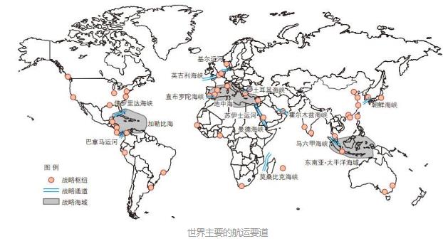
The world's major shipping routes
1. Suez Canal
The Suez Canal was opened to navigation by a French company in 1869. Since then, the Suez Canal has divided the land connecting northeastern Africa and southwestern Asia-the Isthmus of Suez. Since then, the Red Sea and the Mediterranean Sea have been connected. On a broader scale, a more convenient water transport channel has been added between the Indian Ocean and the Atlantic Ocean than in the southern waters of Africa. The voyage between the East and the West has been greatly shortened. For example, the voyage from London to Mumbai has been shortened to about half of the original. Due to the importance of the canal, Britain and France, together with Israel, launched a war for the canal after the war. However, under the pressure of the international community, especially the United States and the Soviet Union, Egypt finally recovered the sovereignty of the Suez Canal from Britain and France. At present, it carries about 14% of the national shipping trade every year. But huge ships of more than 250000 tons cannot pass through this canal.
Areas near the Suez Canal
2. Strait of Malacca
The Strait of Malacca is located between the Indonesian island of Sumatra and the Malay Peninsula on the north side. The country on the north side is Malaysia and the easternmost city-state-Singapore. The strait runs northwest-southeast and connects the South China Sea with the Indian Ocean. The number of oil tankers passing through the Strait of Malacca is three times that of the Suez Canal and five times that of the Panama Canal. For China, Japan, South Korea and other East Asian countries, the Strait of Malacca is a "maritime lifeline" to ensure energy supply"
near the Strait of Malacca
3. Panama Canal
The Panama Canal was excavated by the United States and opened to navigation in 1914. From then on, the American continent separated from the middle into two parts of South America and North America. There was a direct communication channel between the Pacific Ocean and the Atlantic Ocean at low latitudes. The opening of the canal greatly shortened the voyage between Pacific and Atlantic ports, especially for shipping between the east and west coasts of the American continent. Ships traveling between the east and west coasts of the United States originally had to detour Cape Horn in South America. After using the Panama Canal, the voyage can be shortened by about 15000 kilometers. The Panama Canal can generally pass through cargo ships under 50000 tons. On December 31, 1999, the Panamanian government took back control of the canal from the United States.
Near the Panama Canal.
Strait of Gibraltar
The Strait of Gibraltar is located between the Iberian Peninsula at the southwest end of Europe and the northwest of the African continent. The narrowest point is only 13km. It is the only waterway between the Mediterranean and the Atlantic Ocean. This is the only water channel for the Mediterranean and Black Sea coastal countries to enter and exit the Atlantic Ocean. It is also the only place for Northwest Europe and North America to obtain oil from the Middle East. It is currently one of the busiest shipping areas in the world. Due to the extremely important strategic position of the area, the sovereignty of Gibraltar between Spain and the United Kingdom has been disputed until now.
Near the Strait of Gibraltar
5. Strait of Hormuz
The Strait of Hormuz is the world's largest oil and gas producing area-the only waterway from the Persian Gulf to the Indian Ocean, so it is also known as the "oil strait. The strait lies between Iran on the north shore and Oman on the south shore. Most of the oil in the Persian Gulf needs to pass through this strait to reach Western Europe, North America and East Asia, so the strait has a significant impact on the global economy.
Light map near the Strait of Hormuz
6. Turkish Straits
The Turkish Strait (also known as the Black Sea Strait) is the only channel connecting the Black Sea and the Mediterranean Sea, including the Bosporus Strait (also known as the Istanbul Strait), the Sea of Marmara and the Dardanelles Strait (also known as the Canakkale Strait). Both sides of the strait belong to Turkish territory. The first gateway for the Black Sea littoral countries to the farther ocean. In order to fight for the control of the strait in history, various powers broke out many wars, especially the modern Russian Empire and the Ottoman Turkish Empire. To this day, Russia and other countries along the Black Sea are still at odds with the NATO military bloc to which Turkey belongs.
Eastern Mediterranean Lights Chart
7. English Channel
The English Channel, also known as the Ramanch Strait. It is the strait that separates Britain from France on the European continent and connects the Atlantic Ocean with the North Sea. The strait is the only way for the northwest European countries to enter and exit the Atlantic Ocean. Coupled with the huge shipping demand generated by Europe's developed economy, it has always been the busiest shipping waterway in the world.
Western Europe Lights Map
8. The Kiel Canal
Located in northern Germany, it connects the Baltic Sea and the North Sea, also known as the North Sea-Baltic Canal. The opening of the Kiel Canal has greatly shortened the voyage between the North Sea and the Baltic Sea, 370 nautical miles less than the bypass Oresund-Katergart-Skagerrak. The canal has the largest navigable ships of 35000 tons and is currently one of the busiest shipping lanes in the world.
9. Taiwan Strait
The Taiwan Strait is a water channel connecting the East China Sea and the South China Sea. It is a necessary place for my country's eastern coastal ports to connect with the South China coast and even the Indian Ocean coast, Europe and other places. At the same time, it is also of irreplaceable importance to the shipping of South Korea and western Japan.
East Asia Light Chart
10. Korea Strait
The Korean Strait, also known as the Tsushima Strait, is located between Japan's Kyushu Island and South Korea. It is the only channel between the Sea of Japan, the East China Sea and the Yellow Sea. North Korea, South Korea, Japan, Russia and other countries along the Sea of Japan are the only places to pass through the lower Pacific Ocean. In the history of the Russo-Japanese War, a fierce "naval battle against Malaysia" broke out here, and it is still an important water area for the United States, Japan, and South Korea to conduct joint maritime military exercises.
What other important shipping lanes do you know?
Logistics Query
Quickly obtain the latest logistics information


Scan code contact
Address: 25/F Room C,Tower A, Honglong Century Plaza, No. 4002 Shennan East Road,Luo Hu District, Shenzhen, China
Zhongshan Address: Room 805, Floor 8 , Poly Plaza office Building, No. 1 Shiji East Road, Port Town, Zhongshan, Guangdong
Changsha Address: 12020, Building 2, Fudi Xingguang Tiandi, Yuhua District, Changsha .,Hunan
Indonesian company:PT VTOP LOGISTIK INTERNATIONAL
Indonesian address:Jalan Pantai Indah Barat Komplek Toho Blok A No 18 ,Kec.Penjaringan,Kel.Kamal Muara,Jakarta Utara

WeChat ID
Scan code contact